November 2010
This was a really wonderful trip and the names of the places ring with magic sounds of Africa.
It was our fortieth wedding anniversary and Sylvia suggested that maybe we should go to Liuwa Plains with Bhejane 4x4 adventures instead of just going out for lunch or dinner.
As usual we decided to leave early as we like to do a few bits on our own. Before the "main" tour we went to Khama Rhino Sanctuary, LeKhubu Island and Chobe. While with Bhejane on the Liuwa Plains tour we met Schalk and Maarten Potgieter and they invited us to join them at Chobe, Savuti and Moremi after the main tour. We thought this was a lovely idea as we had never done that trip before and knew that there could be some serious 4x4 places especially as the rainy season had started.
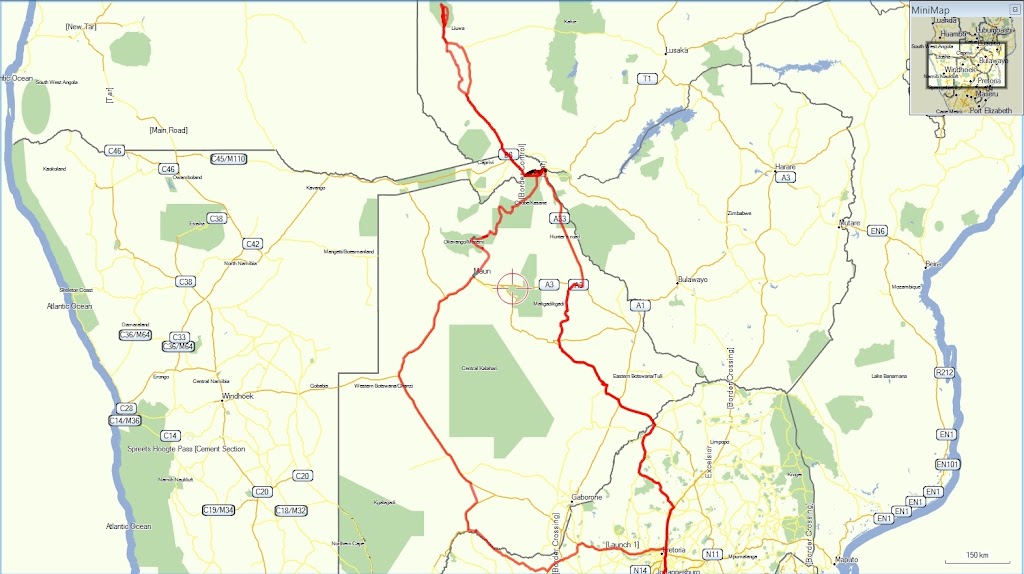
We took the route shown in red - the map above is a screen copy from Tracks4Africa.
Many of the co-ordinates below are taken from Tracks4Africa and they are included because otherwise I get lots of messages asking where the places mentioned are. Also some people will enjoy plotting their own .gdb file in Mapsource.
We used two Garmin 276C GPS units and in some areas the maps from Tracks4Africa mde all the difference. For those intending to do serious trips, especially alone as we often do, having Tracks4Africa is essential for an enjoyable trip. We always arrived at our camp sites on time and the estimated times of arrival made a big difference whether we could linger at places or had to get a move on.
S22.99864 E27.94371 North to Groblersbrug/Martin’s drift – from South Africa into Botswana
S22.23453 E26.72006 Khama Rhino Sanctuary – one special night with the black rhinocerous – two days
S20.89619 E25.82424 LeKhubu Island – one night – the brief windstorm
S17.78530 E25.18313 Kasane - Thebe Lodge – two days in a chalet and start of the Bhejane Tents
S17.84328 E25.14359 Sedudu Gate Chobe - along the river for two days
S17.92638 E24.72027 Ngoma Border Post – from Botswana to Namibia
S17.49648 E24.26910 Total Fuel (Katima Mulilo) – where you buy the Namibian Tax when entering the country.
S17.47303 E24.24391 Shesheke Border control – entering Zambia – expensive and interesting but officials helpful and smiling.
S16.70634 E23.64116 Sioma Camp on the banks of the Zambezi – first night in Zambia
S16.24552 E23.23763 Kalangola – board Sitoti pontoon S16.24393 E23.23778
S15.30475 E23.14921 Mongu Camp – two missionaries – cashew nuts
S15.26253 E23.13411 Kobil Fuel at Mongu – 70 litres and US$120 later
S15.20622 E22.91939 Lealui Pontoon – one of my happy pictures
S14.98726 E22.68372 Kalabo Pontoon (hand drawn) North
Liuwa Plains – the wildebeest – the zebras – the hyenas – Lady Liuwa and her two consorts – those without Tracks4Africa were either gifted navigators or lost.
S14.37578 E22.59819 – the Northernmost point we traveled
S14.98612 E22.68366 Kalabo Pontoon (hand drawn) South
S14.37578 E22.59819 Log Bridge over the Ndonde Canal (creaking wattle)
S16.24393 E23.23778 Camping in the bush
S16.66376 E23.57103 Ngonye Falls – the Zambezi
S16.70634 E23.64116 Sioma Camp – lovely again
Through the borders – filled with petrol at Katima Mulilo – at least 30 litres left so could have been about 50 short if we had not filled at Mongu
S17.78530 E25.18313 Kasane – back to Thebe Lodge – last night in a Bhejane Tent
Chobe in at Sedudu gate S17.84328 E25.14359 - along the river to Serondela Picnic Spot) S17.83967 E25.00799 – south at S17.84109 E25.01617 – across the tar at S17.92213 E25.01939 – south to
Savuti Camp site 2 S18.56430 E24.06343 south to bushman paintings at S18.59385 E24.07939 south to
Moremi North Gate Camp 9 at S19.17129 E23.75368 – out of Moremi through Moremi South Gate (Maqwee Gate) S19.42569 E23.64554
Flight over the Okavango Delta with Sefofane Air Charters S19.97504 E23.42979
Visited Nick Gouws at 4x4 Megaworld S20.01446 E23.43130
Down the A3 to Cornwall S25.26289 E23.48645 for the last night in Botswana – then
Bray S25.45532 E23.71229 and home.
Distance traveled 5306 kilometres.